
Gyroscope Mapping in Utilities

In modern utility management and pipeline maintenance, precision and reliability are critical. At American Pipeline Solutions (APS), we provide advanced gyroscopic pipeline mapping services that give utility operators and pipeline owners a complete understanding of their underground infrastructure. Using cutting-edge gyroscopic technology, APS helps identify pipeline alignment, orientation, and condition without disrupting service, providing actionable insights for pipeline inspection, pressure pipe inspection, and long-term pipeline condition assessment.
Our expertise allows us to deliver highly accurate, real-time data, enabling safer, faster, and more efficient decision-making for pipeline management.
What is Gyroscopic Pipeline Mapping?
Gyroscopic mapping is a non-intrusive method that uses sophisticated gyroscope sensors to measure the orientation, trajectory, and depth of pipelines in three dimensions. The technology allows APS to create a highly detailed digital representation of your pipeline network, helping detect misalignments, bends, or deviations that may compromise pipeline integrity.
Unlike traditional mapping methods, gyroscopic mapping can be performed on live pipelines, ensuring minimal disruption while providing accurate measurements for asset management and maintenance planning.
The Basics of Gyroscopic Mapping
Gyroscopic mapping is a cutting-edge technology that combines gyroscopic sensors, GPS (Global Positioning System), LiDAR (Light Detection and Ranging), and advanced software algorithms to create highly accurate and detailed 3D maps of utility networks and infrastructure. At its core, it relies on the principles of gyroscopes to precisely measure orientation and movement, allowing for the creation of a comprehensive and dynamic digital representation of utility assets.
Pipeline Experts: Inspection, Cleaning, Coating & More
Certified solutions for inspection, pre-commissioning, cleaning, internal coating, ice pigging™, mapping, and turnkey pipeline projects—maximizing safety and reliability at every stage.
Applications in Pipeline & Utility Management
Pipeline Condition Assessment
APS uses gyroscopic mapping to assess the health and stability of pipelines. By precisely mapping the x, y, z coordinates of each section of pipe, our team identifies areas of stress, curvature, or potential failure. This information is vital for proactive pipeline condition assessment, reducing the risk of leaks or downtime.
Pipeline Inspection and Maintenance Planning
Using gyroscopic tools, APS performs comprehensive pipeline inspections that detect deviations, corrosion, and other issues before they become costly problems. These inspections support targeted maintenance and help extend the life of your infrastructure.
Utility Asset Management
Accurate mapping is critical for managing large, complex utility networks. APS provides pipeline mapping services that integrate with GIS and asset management platforms, offering utility operators a clear, digital record of underground pipelines, including depth, trajectory, and orientation.
Emergency Response
During unexpected events such as water main breaks, gas leaks, or pipeline failures, APS’s gyroscopic pipeline mapping data allows for faster response times. Detailed knowledge of pipeline locations and orientations ensures safety for both crews and the public.
The APS Gyroscopic Mapping Process
Our gyroscopic pipeline mapping services follow a precise, multi-step process:
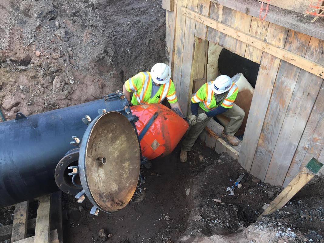
Equipment Setup – A high-precision gyroscopic surveying tool, designed for pipelines, is prepared for deployment.
Deployment – The gyroscopic tool is lowered into the pipeline or launched as a gyro pig, even in live pipelines, and travels along the pipe while collecting data.
Data Acquisition – Sensors measure the pipeline’s orientation in three dimensions, capturing deviations, bends, and depth accurately.
Data Analysis – Collected data is processed to create detailed 2D and 3D maps of the pipeline trajectory.
Report Generation – APS generates comprehensive reports detailing pitch, roll, azimuth, depth, and any deviations detected.
Decision Support – Engineers use the maps and reports to plan maintenance, repairs, or upgrades with confidence.
Compliance Documentation – The mapping data supports regulatory compliance and pipeline integrity management documentation.
Key Benefits of APS Gyroscopic Pipeline Mapping
Precision and Accuracy – Provides highly accurate measurements to within a foot, even for live pipelines.
Non-Intrusive and Safe – Minimal disruption to pipeline operations while eliminating the need for intrusive excavation.
Cost Efficiency – Reduces unnecessary maintenance, optimizes repair schedules, and helps extend pipeline life.
Integrated Data Solutions – Compatible with GIS and other utility management systems for streamlined operations.
Supports Regulatory Compliance – Ensures pipelines meet safety and reporting standards.
Why Choose American Pipeline Solutions?
APS is a trusted provider of gyroscopic pipeline mapping services for utility operators and pipeline owners. Our team combines advanced technology with years of experience to deliver unmatched accuracy and actionable insights. Whether you need pressure pipe inspection, detailed pipeline condition assessment, or precise mapping of underground infrastructure, APS is equipped to provide the solutions you need.
Future of Gyroscopic Mapping
As utility networks become more complex, gyroscopic mapping continues to evolve. Future applications include integrating AI for predictive pipeline maintenance, supporting smart utility grids, and enhancing environmental stewardship through better infrastructure monitoring. APS stays at the forefront of these innovations to ensure clients receive the most reliable and future-proof solutions.
Pipeline Experts: Inspection, Cleaning, Coating & More
Certified solutions for inspection, pre-commissioning, cleaning, internal coating, ice pigging™, mapping, and turnkey pipeline projects—maximizing safety and reliability at every stage.
Conclusion
Gyroscopic pipeline mapping is transforming how utilities monitor, manage, and maintain their critical infrastructure. APS’s services deliver precise data for pipeline inspection, pipeline condition assessment, and pressure pipe inspection, allowing operators to make informed decisions, minimize downtime, and maximize asset life.
Contact American Pipeline Solutions today to schedule a consultation and learn how our gyroscopic mapping services can optimize your pipeline operations.
FAQs:
What is gyroscopic pipeline mapping?
Gyroscopic pipeline mapping is a non-intrusive survey method that uses high-precision gyroscope sensors to measure the orientation, trajectory, and depth of a pipeline in three dimensions. The tool travels inside the pipe and records x, y, and z coordinates along the route, allowing APS to build a detailed digital model of the pipeline’s true alignment, bends, and deviations without excavation.
How does gyroscopic mapping work in pipelines?
A dedicated gyroscopic tool is inserted into the pipeline or launched as a gyro pig and moved along the line, often while the pipeline remains in service. As it travels, onboard gyroscopes and accelerometers record orientation and movement, which are combined with GPS, LiDAR, and advanced software. APS then processes this data to generate accurate 2D and 3D maps of the pipeline’s position, depth, and curvature.
What types of pipelines and utilities can APS map with gyroscopes?
APS can use gyroscopic mapping on a wide range of pressure pipes and utility lines, including water and force mains, gas pipelines, and other buried pressure systems. The technology is especially valuable where as-built drawings are incomplete, where bends and elevation changes are complex, or where traditional locating methods struggle to provide a reliable underground picture.
Does gyroscopic pipeline mapping require a shutdown?
In many cases, no. One of the key advantages of gyroscopic mapping is that it can often be performed on live pipelines, depending on system design and operating conditions. APS evaluates each project to confirm whether the tool can travel safely with the line in service or if temporary flow changes are required, helping minimize downtime and operational disruption.
What information do I get from a gyroscopic mapping survey?
A gyroscopic mapping survey typically delivers detailed 2D and 3D alignment data, including pitch, roll, azimuth, depth, and the precise x, y, z position of the pipeline. APS provides reports and digital files that highlight bends, misalignments, or areas of concern. These outputs can be used for condition assessment, maintenance planning, design work, and long-term asset records.
How accurate is gyroscopic pipeline mapping compared to traditional methods?
Gyroscopic mapping offers high positional accuracy, often within about a foot, even on buried or difficult-to-access pipelines. Unlike surface locating or limited spot measurements, the gyro tool measures the entire pipeline path continuously. This gives utility operators a far more complete and reliable understanding of how the line actually sits in the ground compared to historic drawings alone.
How does gyroscopic mapping support pipeline condition assessment and inspection?
By precisely locating bends, elevation changes, and areas of curvature, gyroscopic mapping helps identify sections where stress, movement, or instability may be more likely. APS uses this data to support pipeline condition assessments, prioritize inspection or pressure pipe inspection, and plan targeted maintenance. Knowing exactly where features and deviations are located also makes future inspection and repair work safer and more efficient.
Can gyroscopic pipeline mapping data be integrated with our GIS or asset management system?
Yes. APS structures gyroscopic pipeline mapping outputs so they can be integrated into GIS platforms and utility asset management systems. This allows operators to overlay pipeline alignment, depth, and orientation data with other system information, improving planning, risk assessment, emergency response, and long-term capital project decisions across the network.
How does gyroscopic mapping help with emergency response and regulatory compliance?
During events like water main breaks, gas leaks, or suspected pipeline failures, accurate alignment data allows crews to locate and access the problem area faster and with less trial-and-error digging. APS’s gyroscopic mapping reports also support regulatory and integrity documentation by providing traceable records of pipeline location, orientation, and condition indicators that can be referenced in safety, risk, and compliance programs.


